

Komodo seen from above, it is even more beautiful
 EN
ENDrones are the new trendy gadget for travelers... On the boat that took me to Komodo, Indonesia, two of my diving buddies have one!
Komodo filmed by a drone
So I have these wonderful images of Komodo seen from the sky at Christoph Würbel, a German expatriate in Asia, based in Singapore, who was like me on vacation in Indonesia in this month of July 2016. (He post more aerial photos here.)
Two months after I came back from this new diving trip in Indonesia, I made a little montage for the blog from his drone videos. So I rediscover them on my computer screen... How beautiful!!! 😮
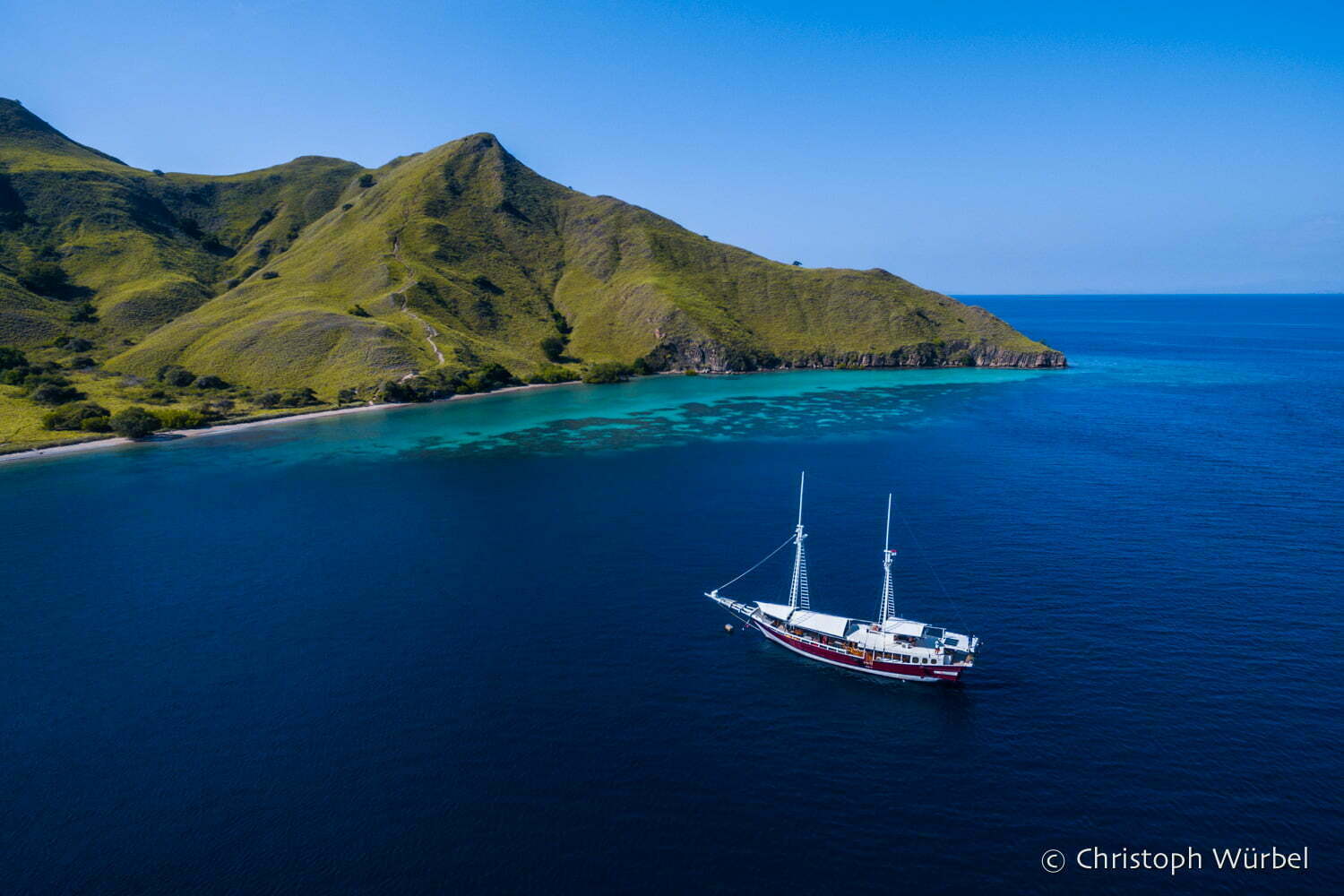
It must be said that this volcanic archipelago of Indonesia is really the ideal place to shoot spectacular aerial images, in fifty shades of blue...
It is composed of three main islands (Komodo, Rinca and Padar) and many smaller ones. To help you to locate, it is here :
This is my second stay in Komodo. I had already dived there during a previous trip in 2011.
The pretty little red and white two-master you see on the video is my new princess boat, the Duyung Baru. I opted, like six years ago, for a small pinisi (a traditional Indonesian boat), all comfort... I embarked with five other divers, for a one week cruise (another solo trip where I never lacked company). Great boat, nice international atmosphere (Germans, Finns, Indonesians, Australians and me, the little French girl), I came back delighted...


In the incredibly fishy waters of the Komodo archipelago, you can observe manta rays from very close, whether you are a simple swimmer with fins, mask and snorkel, or a scuba diver or snorkeler (more underwater pictures to come in a next special manta post)... You can see them well in the drone's video: they are the black diamonds that are outcropping at the surface, around the dinghy!
See also on the blog → In the middle of manta rays in Komodo
The images taken from above show the typical landscape of the archipelago: steep hills covered with savannah, which drop down to white sandy beaches and azure waters, where coral outcrops. The vegetation shows that the climate here is much drier than in other parts of Indonesia.
Even if the archipelago has become quite touristy, one really has a very exhilarating feeling of being at the end of the world when sailing in this intense blue sea dotted with deserted and wild, rather preserved islands. Komodo is a national park, registered on the Unesco World Heritage List and Biosphere Reserves.
How do I get to Komodo? The region is very easy to access from Bali : there are many daily flights to Labuan Bajothe port located on the western end of the island of Flores, just in front of the archipelago. The duration of the flight is about one hour. I prefer to fly with the following companies Garuda and Lion Air / Wings (schedules and rates are on their websites). Update (October 2016): since Jakarta, there is now a direct flight Garuda for Labuan Bajo !

Jurassic Park
Komodo belongs to another world, almost a lost world. Located at the junction of two continental plates, the archipelago is on a volcanic "belt of fire" between Asia and Australia. Unique terrestrial and marine ecosystems have developed there, and one can find species that exist nowhere else!
The most famous one, you may know it: it is the Komodo dragonTourists are allowed to disembark on the islands of Rinca and Komodo to observe them, accompanied by rangers now wearing a jacket with the words "Naturalist Guide" on the back.
Rinca (pronounced "rine-tcha") really has a little side to it Jurassic Park. Listening only to my courage, I left the mantas and the sharks for a few hours to go back to the dragons - old friends, to whom I already went to say hello in 2011... ????
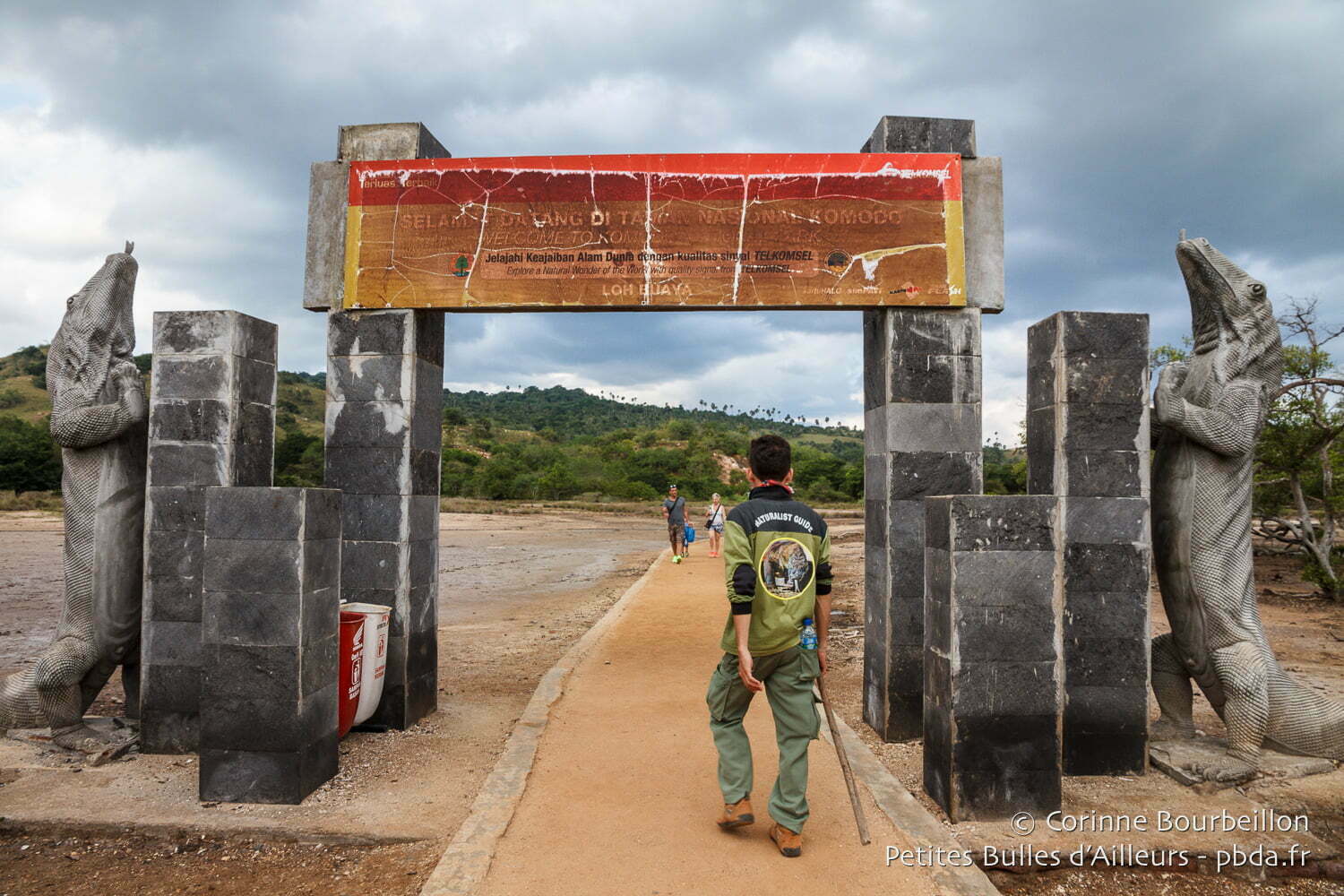

Komodo dragons are very impressive, especially if you are lucky enough to meet some during the trek on the island (and not sleeping near the rangers' garbage cans). But I confess, it is still the creatures that live in the sea water that I prefer to admire and photograph...
The adventurers of the lost path
To conclude this little overview above the surface (while waiting for the underwater images), I leave you with some images of another island, the very photogenic Gili Lawa Darat. It is the one we see at the end of the drone video, with our little group of divers at the top of the high hill overhanging the bay.


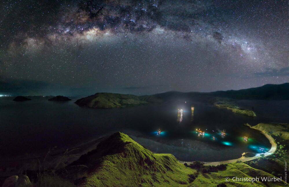
What the video doesn't show is what happens next... Playing drone pilot in beautiful landscapes in broad daylight is one thing. Navigating a deserted island at night is another.
With the other two girls and one of the guys, we left the other boys at the top of the hill with their equipment, because they wanted to stay photographing the sumptuous night sky (I put you above a photo posted on Facebook by Christoph).
Because of a bad choice of path, our panoramic climb turned into an interminable jungle expedition... Yes, Indiana Jones style, in an impassable bush - in shorts, canvas sneakers and flip-flops, of course - by the light of two headlamps and an iPhone flashlight !
I renamed us "The Adventurers of the Lost Trail"... 😂
We finally managed to reach the beach, without breaking. Fortunately that there were no dragons on this island... We would have been probably less intrepid.


So cool! Way to go 😉
@ Jean-François: thx 😉
Hello Corinne,
Thank you for all these photos.
We dream of it already ... ..
Yes, we are going back in December for the 3rd time:
Castle Rock, Crystal Rock, Batu Bolong, Manta Point, etc., we will have the pleasure to go back there.
We would just like to know which other sites you have dived and which ones you have preferred.
Again thank you for making us dream.
We are looking forward to your underwater pictures, we too prefer mantas and sharks to monitor lizards.......!!!!
Alain & Yolande
@Alain & Yolande: We did all the "classic" sites you mention, nothing new, but only good ones: Castle Rock, Batu Bolong, Karang Makassar (Manta Point), The Cauldron, Tatawa Besar... My favorites: Batu Bolong always teeming with life, Karang Makassar (Manta Point) full of mantas, as well as Castle Rock with impressive schools of jacks to turn around... We gave up some sites, because we were right in the full moon, with currents which, as you know, can be really problematic, especially since the levels were unequal in our small group of divers. Everybody was able to have fun, photographers with a lot of gear like me, as well as those who had never used a hook underwater before...
😎
To the adventurer who has returned from her lost path, I say bravo!
@Ysbilia: fortunately it was not the path of the lizards... Not very nice, these beasts... 😉
Sublime! Thank you for these beautiful images that make you dream 🙂
@Tonton Photo: must say that the place is photogenic as possible... 😉
Oh sure, the video with the drone, it's a blast! I will certainly launch myself one day in this adventure... Superb as always !
@Didier: I'm starting to see drones regularly, during my trips to Asia. It's really becoming more democratic. But it makes a hell of a mess to carry around as well... 🙂
Oh boy... this is really super beautiful!!!
@LadyMilonguera: yes, the landscapes of Komodo are fantastic!
This is beautiful, what beauty and calm in these images!!!
@Evarist: you just have to open your eyes wide to see all this beauty...
This country is crazy! we have been thinking about it for a number of years now. Thank you for these photos and impressions that give even more desires.
@A couple on the mop: do not hesitate any more...
The photos are crazy!
If we could have stayed longer in Indonesia and visited another island, we would have most certainly gone to Komodo. Considering these crazy pictures, we'll really have to come back to this incredible country 🙂
I rediscover this site after experiencing it at the beginning when I also accumulated miles to Indonesia. Children shorten travel but not emotions. This site has undergone a great evolution. 17 trips to Indonesia in 9 years !!! You will be able to open a commission nasi goreng to the federation !!!
@Bertran: I had not counted the exact number of trips to Indonesia since 2006, the beginning of this blog. Especially since there were others before. It's true that it starts to make... Besides, I already plan an 18th one in July 2017, hey, hey... Commission nasi goreng ? I'll take it!!!
Wow! To fall! We were supposed to go to Komodo, but we finally opted for the north of Bali and Menjangan. But it looks fantastic Komodo! I heard about strong currents... Is it true? And in terms of accommodation, any tips or to do by boat cruise instead? Thanks for your information. Your pictures are fantastic!
@Anne: in July 2016, it was my second time in Komodo. I am very late, I have not yet managed to post the story of my dives this summer...
My first experience of Komodo was in 2011, that's when I started (like you in Raja Ampat) to crochet...
https://petitesbullesdailleurs.fr/voyage-flores-bali-indonesie-2011/
So yes, in Komodo, the currents are impressive (some of them are descending) and they can be dangerous, if you are not with people who know the sites and the tides well, who know where and when to take you diving, adapting the difficulty to the level of the group... Every year, there are people who are carried away from the boats (I don't know if you remember the story of divers who ended up stranded on a beach where they had to chase away the inquisitive monitor lizards with stones all night long, before they were found the next day...).
During this very nice cruise on the Duyung Baru, we were divers of various levels, and I was encumbered like my partner with a big camera. So Vovo, the German who was in charge of the organization of our dives and who knows perfectly the park, preferred to avoid us dives too complicated or too sportive, we gave up some sites, because we were right at the full moon, when there is really a lot of juice... But we enjoyed ourselves anyway, not to say "gorged", with a profusion of mantas in Karang Makassar in particular, and the always magnificent site of Batu Bolong.
Komodo is best done on a cruise (even a short cruise of 4-5 days), because from Labuan Bajo, it is still a long way to reach the sites, on a day trip, and so you can't really enjoy them or discover them all...
If you have taken a liking to Indonesia, Komodo is really a mythical spot, to discover absolutely, by coupling with the excursions in the islands of the archipelago, and by also taking the time if possible to visit the immense and magnificent island of Flores, which has a lot to offer.
In short, I place Komodo in my top 3 staff of great dive sites in Asia, with Raja Ampat and Sipadan ...
Fell on this nice blog by chance, following the video of the video below, with also beautiful pictures of Raja Ampat's drone:
https://www.youtube.com/watch?v=78P0d4BPXcw
fabulous trips that makes you want!
in this regard, we go with family (6 adults and 2 teens: 13 and 16 years) from 27-12 to 3-01, normally in Komodo and South Florés. Diving baptism for teens and their parents, who are eagerly waiting for it, could you give me your opinion on this project, and / or another place in Indonesia, where my little girls will be able to admire multicolored fish and other corals, snorkeling and diving, we will be in the rainy season!
Thank you.
clear,
@taxil: Hello Claire, thank you for taking the time to leave a note! Yes, late December - early January is not the ideal season to visit Indonesia. And for Komodo/Flores, it is in principle the moment when we really enter the rainy season. I can only refer you to this page which summarizes (in English) what you can expect, in terms of climate, in the region (see the table month by month at the bottom of the page):
http://www.komodo.travel/komodo-national-park/komodo-weather/
But of course, weather is not an exact science, and the rainy season can be early or late... If there is one thing that is difficult to anticipate in Indonesia, it is the weather. Sometimes we go to areas supposed to be in dry season and we get rain, and sometimes by going in wet season in other places we have a great sun... I refer you to this page (in English) of a great connoisseur of Indonesia, which explains that very well:
http://www.east-indonesia.info/planning/indonesia-travel-information-climate-timing.html
In principle, the Flores/Komodo area is less wet than others, all year round. But in case of bad weather (wind and showers) it will not be a pleasure to sail from one island to another in Komodo. From 27/12 to 03/01, that's only 8 days, if I count correctly... I think it's maybe a bit short, given the weather uncertainty, if you have a really bad week (but you can also have a great sunny week).
Also remember that bad weather can cause problems with transportation to and from Flores (delayed or cancelled flights, impassable roads, etc.), so don't be too tight on your flight connections, it's more prudent.
There are plenty of other places in Indonesia to swim and see fish (Bali, Sulawesi, Borneo...) but you will be confronted with the same uncertainties about the weather. The two regions where the season is considered "dry" while the rest of the country is in "wet" season are the Moluccas and Raja Ampat. But it is farther and less easy to access than Flores and Komodo, if you only have 8 days it would be a pity to waste a day at each end in transportation...
Anyway, Flores is a beautiful island to discover and even in the "wet" season I think it is worth it. With a bit of luck, you will only have a few showers from time to time, nothing that prevents you from moving and visiting...
PS. And I add this link (in French), which recapitulates well the complexity of the Indonesian climate:
http://www.climatsetvoyages.com/climat/indonesie
🙂
Wow, I'm blown away by the speed, accuracy and the time you took to answer me!
I didn't want to monopolize your blog, that's why my message was quite short.
I'll add, just, some info: we leave on December 17, arriving on the 18th in Singapore. 2 nights in this city, then Jakarta, Bandung, Pangandaran, Yiogiakarta ... Kawah ijen .... I wanted to book 9 to 10 days snorkelling and diving, my little girls are waiting with such impatience! But here I block on the choice: Moluccas? Do you know?
return Thursday, January 4th from Singapore at 23:05.
in any case, I will not miss my return to come on your blog, to share my info.
Thank you.
Clear.
@taxil: the Moluccas, it's a group of islands, between Sulawesi and Papua... I don't know them very well, it's always a bit far and complicated to go there compared to other more accessible destinations in Indonesia. Some posts below:
Central Moluccas : I passed by Banda Neira during a dive cruise in 2015 from Ambon :
https://petitesbullesdailleurs.fr/banda/
North Moluccas: I stayed in Weda Bay in Halmahera in 2013
https://petitesbullesdailleurs.fr/weda/
For snorkeling and diving, even if it's not the best of the season, maybe stick to the idea of aiming for Bali and/or Komodo, there are plenty of laisons and a lot of choices in terms of tourist facilities and spots.
Big thanks.